
Taking Shape
Model a remote sensing device called LiDAR by engineering a technology to produce a 3D image of a landscape.
Guiding Question
How can we gather information about topography?
Setup
The Educator Guide has a script, materials list, and prep directions. Be sure to have it open and ready to help guide you through every activity.
- Post the Engineering Design Process poster.
- Bundle a handful of straws together using a rubber band or craft foam and tape, to demonstrate how youth can keep the straws packed together in their model LiDAR device.
- Create a Materials Table with the materials listed on Educator Guide p. 41.


Youth Will Know
- Scientists and engineers use remote sensing devices to gather information about the topographical features of a landscape.
- Engineers often use models to represent the technologies or materials they are investigating.
Youth Will Do
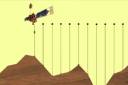
- Use straws as a model for LIDAR.
- Record information about a surface.
- Discuss limitations of the model.
Did you know?
- Some animals, such as bats and whales, have evolved the ability to remotely sense their surroundings using sonar, which relies on bouncing sound waves instead of light.
Quick Tips
- Consider playing videos for youth to review LiDAR.
- Encourage youth to try out different materials or combinations to keep the straws together.
- As an alternative to drawing, have groups trace the topography by using the shape of the straw tops held up to paper.